


la BOURBOULE CHARLANNE

SUPERMAMINOU2004
User
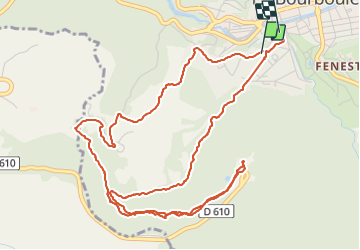

Length
7.1 km

Max alt
1157 m

Uphill gradient
300 m
Km-Effort
11.1 km

Min alt
854 m

Downhill gradient
316 m
Boucle
Yes
Creation date :
2021-08-27 08:56:07.024
Updated on :
2021-08-27 11:16:41.083
2h20
Difficulty : Medium

FREE GPS app for hiking
 SityTrail
IGN / Geographical institutes
SityTrail Plus
The world is yours!
About
Trail Walking of 7.1 km to be discovered at Auvergne-Rhône-Alpes, Puy-de-Dôme, La Bourboule. This trail is proposed by SUPERMAMINOU2004.
Positioning
Country:
France
Region :
Auvergne-Rhône-Alpes
Department/Province :
Puy-de-Dôme
Municipality :
La Bourboule
Location:
Unknown
Start:(Dec)
Start:(UTM)
479438 ; 5048074 (31T) N.
Comments